Wintery weather expected to arrive after midnight, snow mixed with sleet
Having last week been introduced to Bangor Sgt. Tim Cotton and his daily musings, crime updates and news alerts on the Bangor Police Department's Facebook page, this afternoon, as the first nasty winter storm is bearing down on the state, we're going to share his advice.
"Tuesday: Get up early, clear the snow, warm up the Packard and leave for work a little ahead of schedule and avoid collisions."
Like Cotton also said today on Facebook: "The issue that seems to manifest itself on those snowy days is that we all start running a little late. If we all made a pact to get up at least one half hour earlier tomorrow morning, we will not be forced to try to make up the lost time on our drive in to work. Now, if we can avoid buying up all the bread at Hannies, I think we have winter licked."
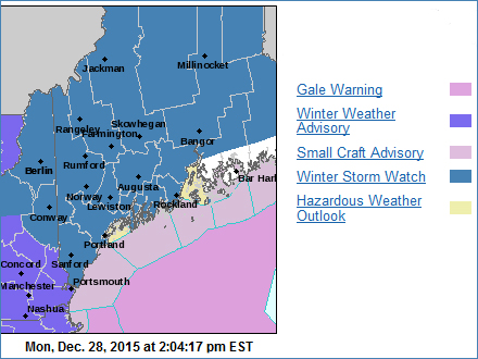
Monday afternoon, Maine remains under a winter storm watch, according to the National Weather Service. Wintery weather is expected late Monday night into Tuesday, with snow spreading into southern New Hampshire after midnight and gradually spreading into Maine by daybreak Tuesday.
Snow will mix with or change to sleet by the morning hours in southern New Hampshire and then southwest Maine, as warmer air moves in above.
Heavier precipitation will come to an end early Tuesday evening, tapering off to freezing drizzle overnight.
Snow accumulation of 6 to 10 inches is in the current forecast, along with a trace of ice. The NWS said that snow covered roads and slush will make for difficult travel.
Winds will be east, 5-15 mph with gusts up to 25 mph, and temperatures will be in the single digits increasing into the mid-20s Fahrenheit.
Event Date
Address
United States


 presents a dyptych pastel by the late Paul Plante to lucky winner Ali Dailey.")