Winter storm warning for the Midcoast, 5-7 inches of snow on the way Monday
GRAY — Quoting the National Weather Service, "...Spring opens the door with snow forecast for southern Maine and southeastern New Hampshire."
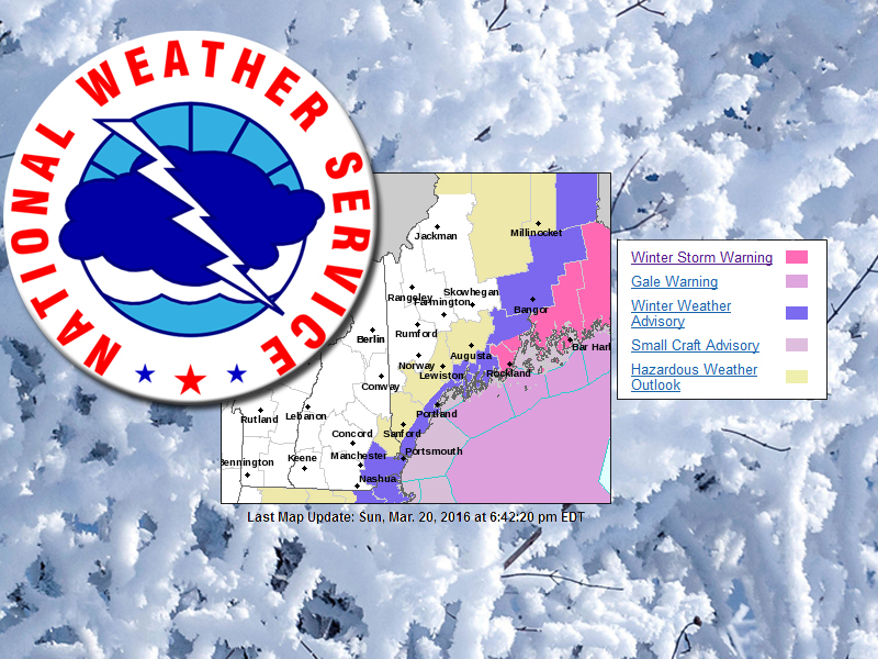
Low pressure will develop southeast of Long Island, N.Y., late Sunday before passing just east of the Gulf of Maine Monday. This system will bring heavy snow to the state, with the bulk of it falling along and near the coastline.
The highest snowfall totals from this system should fall over communities along the Penobscot Bay region, according to the NWS, as those areas will be closest to the track of the low.
A winter storm warning has been issued for the Midcoast and Downeast portions of the state, in effect from 2 a.m. to 6 p.m. Monday, March 20.
As of late Sunday afternoon, the forecast is for accumulations of 4 to 7 inches around Knox County and coastal Waldo County. The snow is expected to arrive late Sunday night and continue through the afternoon Monday.
This storm will bring with it winds of 5 to 15 mph, with gusts up to 25 mph and temperatures in the upper 20s Fahrenheit.
The forecast through the first week of spring looks pretty much like winter, so brace yourselves. Mother Nature is not quite done with us when it comes to cold, wet and some more white stuff as we head into the final two weeks of March.
The detailed forecast through Friday, March 25, follows:
Sunday overnight: Increasing clouds, with a low around 22 F. East wind around 5 mph. Chance of precipitation is 60 percent. Total nighttime snow accumulation of around an inch possible.
Monday: Snow, mainly between 5 a.m. and 5 p.m. High near 33 F. North wind 10 to 15 mph. Chance of precipitation is 100 percent. New snow accumulation of 3 to 7 inches possible.
Monday night: A chance of rain and snow before 7 p.m., then a chance of snow between 7 and 9 p.m. Mostly cloudy, then gradually becoming mostly clear, with a low around 22 F. West wind around 15 mph. Chance of precipitation is 30 percent. New precipitation amounts of less than a tenth of an inch possible.
Tuesday: Sunny, with a high near 38 F. West wind around 15 mph.
Tuesday night: A 40 percent chance of snow after 10 p.m. Mostly cloudy, with a low around 29 F. Southwest wind 5 to 10 mph.
Wednesday: Partly sunny, with a high near 42 F.
Wednesday night: Mostly cloudy, with a low around 22 F.
Thursday: A chance of snow between 9 a.m. and 3 p.m., then a chance of freezing rain after 3 p.m. Mostly cloudy, with a high near 34 F. Chance of precipitation is 30 percent.
Thursday night: A chance of freezing rain before 9 p.m., then rain and snow showers likely. Cloudy, with a low around 31 F. Chance of precipitation is 60 percent.
Friday: Rain and snow showers likely, becoming all rain after 9 a.m. Cloudy, with a high near 42 F. Chance of precipitation is 60 percent.
Friday night: Rain and snow showers likely. Mostly cloudy, with a low around 27 F. Chance of precipitation is 60 percent.
Event Date
Address
United States


 presents a dyptych pastel by the late Paul Plante to lucky winner Ali Dailey.")