Maine Dept. of Marine Resources closes parts of Penobscot Bay to scallop harvest
Effective Feb. 2, parts of Penobscot Bay are closed to scalloping, as the state attempts to protect the scallop broodstock.
“The Commissioner adopts this emergency rulemaking to establish scallop conservation closures within Middle Penobscot Bay Islands, and also, Somes Sound and Cranberry Isles in Zone 2,” said the DMR in a Jan. 30 announcement. “The Department is concerned that continued harvesting for the remainder of the 2019-2020 fishing season in these areas will reduce scallop broodstock further, as well as jeopardize sublegal scallops that were observed in the 2019 Spring Scallop survey that is essential to the ongoing recruitment, regrowth and recovery of the scallop resource. An immediate conservation closure is necessary to reduce the risk of unusual damage and imminent depletion of the scallop resource in the Middle Penobscot Bay and Cranberry Isles areas.”
Targeted closures are imposed as conservation measures to assist in rebuilding specific areas of the state, the DMR said in its rule making.
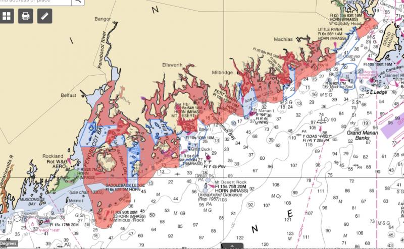
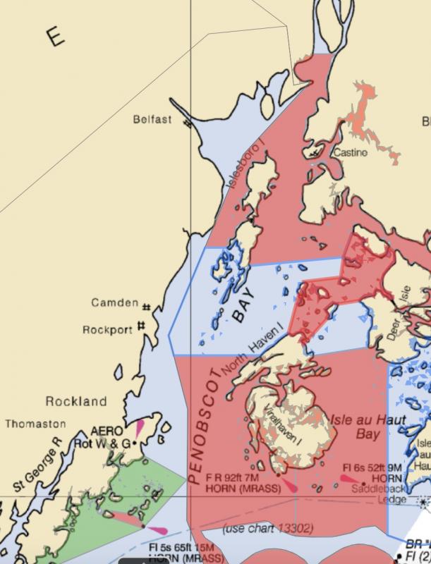
The Penobscot Bay closed area’s western boundary is east of a line starting at the northern tip of Webster Head, North Haven, and running northerly to the southern tip of Great Spruce Head Island; continuing along the western shore of Great Spruce Head Island to the eastern tip and running easterly to the northwestern tip of Bradbury Island; and then running northerly o the western tip of Pickering Island.
Transiting exception:
Any vessel possessing scallops onboard, may transit these targeted closures only if the vessel has all fishing gear (dredges, drags, regulators, buoyancy compensators, fins, tanks, weight belts) securely stowed. Securely stowed shall mean the main wire shall not be shackled or connected to the dredges or drags, and the towing swivel will be at block or on the winch for draggers, while regulators, buoyancy compensators and tanks should be disconnected with fins and weight belts removed for divers.
Lower Muscle RidgeSouthern boundary: North of a line starting at the most southern point of Whitehead Island, St. George, to the southern end of Two Bush Island.
Northern boundary: East and South of a line beginning at the most eastern tip of Whitehead Island, St. George, to the southern tip of Seal Island (Hay Ledges) continuing to the most southwestern point of Graffam Island, then continuing to the southwestern point of Pleasant Island and continuing in a southeasterly direction to the northeastern tip of Two Bush Island.
Eastern Casco BayWestern boundary: East and North of a line draw from R N “2” at Eastern Drunkers Ledge to the most southern tip of Jaquish Island; then east of a line from the most northwestern tip of Jaquish Island at Latitude 43o 42.950N Longitude 70o 00.137W to the most southeastern tip of land along Jaquish Gut at Latitude 43o 43.043N Longitude 70o 00.128W.
Eastern boundary: West and North of a line drawn from the most southern tip of Gun Point, Harpswell, to G “3”, South of Round Rock; continuing in a southwesterly direction to R N “2” at Eastern Drunkers Ledge.
Upper Sheepscot RiverSouthern boundary: North of a line drawn from the most southern point of Kehail Point running northeasterly to the most southern point of Barters Island and continuing southeasterly to the most northwestern tip of Sawyer Island.
Eastern boundary: West of a line drawn at the most northern tip of Soldier Point running north to the most southern tip of Westport Island.
Western boundary: East of a line drawn from the most southern tip of Hockomock Point, Woolwich to the most northern tip of Mill Point, Arrowsic Island, and following the shoreline to the Arrowsic Island-Georgetown Island bridge, and then continuing along the northern coastline to the northeast tip of Dry Point, Georgetown Island.
New Meadows River
DEPARTMENT OF MARINE RESOURCES
Southeast boundary: North of a line drawn from the southernmost tip of Birch Point, Phippsburg, to the southernmost tip of Long Island, Harpswell, then continuing along the western coastline to the northern tip of Long Island, Harpswell, then a line drawn due west to the nearest point of land on Sebascodegan Island, Harpswell.
Southwestern boundary: North of the Route 24 Gurnet Bridge (Harpswell).
West of a line drawn from the southeastern most tip of Pinkham Point, Harpswell, in a southwesterly direction to the nearest point of land and to include all of Card Cove, Harpswell.
- Beals-Jonesport BridgeWestern boundary: East of the Jonesport-Beals Bridge.
- Eastern boundary: West of a line drawn from the most eastern tip of Perio Point, Beals to OW Look’s wharf, Jonesport.
- Damariscotta River
- North of a line drawn from Emerson Point at the southern most tip of Ocean Point in the town of Boothbay, easterly to Thrumcap Island, then northerly to the southern tip of Rutherford Island, South Bristol.
- Moosabec Reach within Chandler Bay/Head Harbor Island Rotational Area
- Inside and west of a line starting at the eastern tip of Kelley Point, Jonesport and running southwesterly to the eastern tip of Pig Island; and, continuing southwesterly to the northeastern tip of Great Wass Island.
- Upper Narraguagus Bay within Narraguagus/Pigeon Hill Bay Rotational Area
- North of a line starting at the southern tip of Flint Island and running westerly to the southern tip of Shipstern Island, continuing southwesterly to the southern tip of Jordans Delight, continuing to the southern tip of Bois Bubert Island; and, continuing north along the eastern shore of Bois Bubert Island to the northern tip and running north to Tom Leighton Point, Milbridge.
- Chandler and Eastern Bay within Chandler Bay/Head Harbor Island Rotational AreaSouthern Boundary: North of a line starting at the eastern tip of Mud Hole Point, Great Wass Island running easterly to the western tip of Brim Cove, Steele Harbor Island; continuing along the northern shore to the northern side of Upper Herring Cove, Steele Harbor and running easterly to the southern tip of Man Island; continuing along the eastern shore of Man Island to the northern tip of Man Island and continuing to the southern tip of Head Harbor Island.
- Eastern boundary: West of a line starting at the southern tip of Bonney Point, Roque Island and running southerly to the eastern tip of Mark Island; continuing southerly to the eastern tip of Sequin Island; and, continuing southerly to the shore of Head Harbor Island.
- Middle Penobscot Bay Islands within Middle Penobscot Bay Rotational Area
- Western boundary: East of a line starting at the northern tip of Webster Head, North Haven and running northerly to the southern tip of Great Spruce Head Island; continuing along the western shore of Great Spruce Head Island to the eastern tip and running easterly to the northwestern tip of Bradbury Island; and then running northerly o the western tip of Pickering Island.Eastern boundary: West of a line starting at the southern prominent point of Marsh Cove, North Haven and running northeasterly to the southern tip of Eagle Island; continuing along the eastern shore of Eagle Island to the northeastern tip and then running easterly to the western tip of Dunham Point, Deer Isle.
North of a line starting at the eastern tip of Seawall Point, Mount Desert Island and running easterly to the western tip of Great Head, Great Cranberry Island; continuing along the southern shore of Great Cranberry Island to Deadman Point; then running easterly to the southern tip of Baker Island and continuing along the southern shore to the eastern tip of Baker Island; and running northerly to Otter Point, Mount Desert Island.
Event Date
Address
United States