Yachting Solutions proposal affected by proposed harbor channel language changes
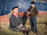
") Landmark Engineer Mike Sabatini points to how Yachting Solutions' channel design lines up with current ordinance language. (Photo by Sarah Thompson)
Landmark Engineer Mike Sabatini points to how Yachting Solutions' channel design lines up with current ordinance language. (Photo by Sarah Thompson)
") (Photo by Sarah Thompson)
(Photo by Sarah Thompson)
") (Photo by Sarah Thompson)
(Photo by Sarah Thompson)
") (Photo by Sarah Thompson)
(Photo by Sarah Thompson)
") Christos Calivas, of SHIP, agrees with Sabatini that more constructive conversation is necessary. (Photo by Sarah Thompson)
Landmark Engineer Mike Sabatini points to how Yachting Solutions' channel design lines up with current ordinance language. (Photo by Sarah Thompson)
(Photo by Sarah Thompson)
(Photo by Sarah Thompson)
(Photo by Sarah Thompson)
Christos Calivas, of SHIP, agrees with Sabatini that more constructive conversation is necessary. (Photo by Sarah Thompson)
Christos Calivas, of SHIP, agrees with Sabatini that more constructive conversation is necessary. (Photo by Sarah Thompson)
Landmark Engineer Mike Sabatini points to how Yachting Solutions' channel design lines up with current ordinance language. (Photo by Sarah Thompson)
(Photo by Sarah Thompson)
(Photo by Sarah Thompson)
(Photo by Sarah Thompson)
Christos Calivas, of SHIP, agrees with Sabatini that more constructive conversation is necessary. (Photo by Sarah Thompson)
ROCKLAND — If enacted, a proposed language change regarding a channel in Rockland Harbor would impact a harbor marina project proposed by Yachting Solutions. Yet, if language is not altered and coordinates are not identified, liability of boat owners within the mooring field could likewise be affected.
Instead of continuing through final reading and public hearing next Monday, May, 13, Councilors will request postponement of Ch. 9, Sec. 9-202 Clarifying Designation of Channel so that YS can appeal to the Harbor Management Commission.
According to Mike Sabatini, of Landmark Corporation, which serves as engineers for the Yachting Solutions’ proposed marina expansion, the expansion’s architects had plotted the channel based on current ordinance language.
Through the past year, YS has invited City and public opinion of the important aspects of the harbor. Sabitini referred to YS’s willingness to involve residents as a good-faith gesture. But it didn’t go over well, according to him.
“We heard loud and clear that the informal channel must be protected,” he said. “The informal channel on this map is as described in the existing language in the ordinance. It says ‘a channel from the area of the Rockland Public Landing zone.’ That’s what that line [on the diagram] represents...to a certain extent. It is grid-east instead of true east.”
“Certainly I think there’s a need to talk about this more, in a constructive setting,” he said. “I think there’s probably a good solution for everyone here that perhaps minimizes moving moorings and allows YS to have some marina expansion.”
As clarified by Christos Calivas, of the harbor advocacy group Sensible Harbor Infrastructure Plan (SHIP), current language states “at a point that begins at the Public Landing, and running due-East 0-9-0-true. And its width being 80ft, and 400 yards long.”
That language, however, only identifies the coordinates at the beginning of the channel, at the Public Landing. The proposed language continues identifying coordinates to the rest of the channel.
Because Army Corps and the Coast Guard consider Rockland’s mooring field the same as open ocean, “if you are on a mooring, you have to have an anchor light,” said Council member Ed Glaser.
By determining the channel’s coordinates, the moorings can be marked, and the field can potentially be designated as a special zone where moorings don’t require illumination, according to Glaser.
“It’s a simple thing,” he said, “but it protects people from liability once they are in the mooring field. You can’t do that if you have a channel basically through there without coordinates.”
The language change would also create a buffer area adjacent to the channel so that moored boats don’t drift into the construction zone.
The proposed language change “was an attempt to use what’s there and meld it with the City ordinance, and clarify it,” he said.
“It’s just a matter of where we want [the channel] to start” he said. “Do we want to move it a little bit so that they have room to build their project? Or do we want to keep it where it has been?”
Reach Sarah Thompson at news@penbaypilot.com
Event Date
Address
United States