UPDATED: Midcoast added to winter storm warning
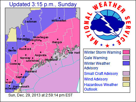
GRAY — The arrival of Sunday's storm later this afternoon is consistent statewide, but the snow-rain mix line travels as far up the coast as Knox County, with points north likely to see all snow and accumulations of up to 10 inches of it.
Despite the likelihood of warmer temperatures and snow changing to rain at times up through the Midcoast, Knox and Lincoln counties could see 3 to 6 inches of snow before the storm departs early Monday morning.
An late Sunday afternoon forecast from the National Weather Service has placed the Midcoast, down to Portland, under a winter storm warning through 4 a.m. Monday, Dec. 30. The precipitation may begin as rain along the coast before changing to snow, which will be heavy and “sticky,” falling at rates of 1 to 2 inches or more per hour tonight.
For Knox and Lincoln counties, snow accumulations of 4 to 8 inches away from the shoreline are forecast, and the immediate coastline may see more rain than snow. For Waldo County, snow accumulations of 6 to 10 inches are predicted, with little or no changeover to rain.
Heavy, wet snow statewide will cause travel difficulties, and areas with ice still on trees may be susceptible to accumulations, broken limbs, downed utility lines and power outages.
Along the coast, winds will be north at 15 to 15 mph and gusting to 30 mph, with temperatures in the upper 20s. Inland, winds will be north at 5 to 10 mph, with temperatures also in the upper 20s. For both, visibilities may drop to 1/4-mile at times.
During a winter storm warning, dangerous travel conditions are likely so only emergency travel is suggested. If you must travel, drive with extreme care and bring some emergency supplies in case you get stranded.
Today’s storm will usher in frigid temperatures for the New Year, as temperatures will drop and average 10 to 20 degrees below normal from Tuesday, Dec. 31 through Saturday, Jan. 4. There will also be dangerous wind chills well below zero next week. As of Sunday morning, the NWS is also tracking another low that it says will bring a “general snowfall” to the region Thursday night, Jan. 2, into Friday as it tracks just to the south.
For updated NWS weather, click here.
The extended forecast for the Midcoast follows.
Sunday night: Rain and snow before 3 a.m., then a chance of snow. Low around 24 F. Blustery, with an east wind 10 to 15 mph becoming north 20 to 25 mph after midnight. Chance of precipitation is 100 percent. New snow accumulation of less than a half inch possible.
Monday: Partly sunny, then gradually becoming sunny, with a high near 31 F. Blustery, with a west wind 5 to 15 mph increasing to 15 to 25 mph in the afternoon.
Monday night: Mostly clear, with a low around 2 F. Wind chill values as low as minus 15. Northwest wind 10 to 15 mph.
Tuesday: Mostly sunny, with a high near 13 F. North wind 5 to 10 mph.
Tuesday night: Mostly cloudy, with a low around 6 F.
Editorial Director Holly S. Edwards can be reached at hollyedwards@penbaypilot.com or 706-6655.
Event Date
Address
United States