January 13 storm arrives: Blustery, damp, cold, as ocean again washes over land
") The entrance to Rockport Harbor, Jan. 13, 2024. (Photo courtesy Peter Ralston)
The entrance to Rockport Harbor, Jan. 13, 2024. (Photo courtesy Peter Ralston) Camden Harbor at high tide, Jan. 13.
 ") In Thomaston (Photo courtesy Kathleen Norton)
In Thomaston (Photo courtesy Kathleen Norton) Bay View Landing, Camden, Jan. 13.
 Bay View Landing in Camden Jan. 13.
 Camden Harbor, Jan. 13
 Bay View Landing, Camden, Jan. 13.
 The Camden Public Landing was closed off to vehicular traffic Jan. 13.
 Bay View Landing, Camden, Jan. 13.
") In Thomaston (Photo courtesy Kathleen Norton)
In Thomaston (Photo courtesy Kathleen Norton)") In Thomaston (Photo courtesy Kathleen Norton)
In Thomaston (Photo courtesy Kathleen Norton)") In Thomaston (Photo courtesy Kathleen Norton)
In Thomaston (Photo courtesy Kathleen Norton)") Bay View Street in Camden was crowded with people heading to the waterfront to watch how the storm affected the waterfront at high tide. (Photo courtesy Camden Fire Dept.)
Bay View Street in Camden was crowded with people heading to the waterfront to watch how the storm affected the waterfront at high tide. (Photo courtesy Camden Fire Dept.)") Camden Harbor (Photo courtesy Camden Fire Dept.)
Camden Harbor (Photo courtesy Camden Fire Dept.) A boathouse on Camden Harbor was shoved askew by the ocean Jan 10, and buffeted again on the shore, Jan. 13.
 What initially looked like a boardwalk alongside the Camden Harbor is really a pier that washed onto land.
 At Steamboat Landing, in Camden, there is nothing but broken piers, upturned granite and concrete ramps, and rubble.
  A pier has been dragged up onto Steamboat Landing, in Camden.
  Steamboat Landing, Camden. Currently unusable for any mariners hoping to come ashore on the boat ramp.
 A picnic table has been partially buried in storm rubble at Steamboat Landing in Camden.
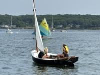
 On Jan. 13, Camden took on the look of a predominantly working harbor, with visiting fishing vessels finding safe harbor from the storm.
  Camden Harbor, Jan. 13.
The entrance to Rockport Harbor, Jan. 13, 2024. (Photo courtesy Peter Ralston)
Camden Harbor at high tide, Jan. 13.
In Thomaston (Photo courtesy Kathleen Norton)
Bay View Landing, Camden, Jan. 13.
Bay View Landing in Camden Jan. 13.
Camden Harbor, Jan. 13
Bay View Landing, Camden, Jan. 13.
The Camden Public Landing was closed off to vehicular traffic Jan. 13.
Bay View Landing, Camden, Jan. 13.
In Thomaston (Photo courtesy Kathleen Norton)
In Thomaston (Photo courtesy Kathleen Norton)
In Thomaston (Photo courtesy Kathleen Norton)
Bay View Street in Camden was crowded with people heading to the waterfront to watch how the storm affected the waterfront at high tide. (Photo courtesy Camden Fire Dept.)
Camden Harbor (Photo courtesy Camden Fire Dept.)
A boathouse on Camden Harbor was shoved askew by the ocean Jan 10, and buffeted again on the shore, Jan. 13.
What initially looked like a boardwalk alongside the Camden Harbor is really a pier that washed onto land.
At Steamboat Landing, in Camden, there is nothing but broken piers, upturned granite and concrete ramps, and rubble.
A pier has been dragged up onto Steamboat Landing, in Camden.
Steamboat Landing, Camden. Currently unusable for any mariners hoping to come ashore on the boat ramp.
A picnic table has been partially buried in storm rubble at Steamboat Landing in Camden.
On Jan. 13, Camden took on the look of a predominantly working harbor, with visiting fishing vessels finding safe harbor from the storm.
Camden Harbor, Jan. 13.
Camden Harbor, Jan. 13.
The entrance to Rockport Harbor, Jan. 13, 2024. (Photo courtesy Peter Ralston)
Camden Harbor at high tide, Jan. 13.
In Thomaston (Photo courtesy Kathleen Norton)
Bay View Landing, Camden, Jan. 13.
Bay View Landing in Camden Jan. 13.
Camden Harbor, Jan. 13
Bay View Landing, Camden, Jan. 13.
The Camden Public Landing was closed off to vehicular traffic Jan. 13.
Bay View Landing, Camden, Jan. 13.
In Thomaston (Photo courtesy Kathleen Norton)
In Thomaston (Photo courtesy Kathleen Norton)
In Thomaston (Photo courtesy Kathleen Norton)
Bay View Street in Camden was crowded with people heading to the waterfront to watch how the storm affected the waterfront at high tide. (Photo courtesy Camden Fire Dept.)
Camden Harbor (Photo courtesy Camden Fire Dept.)
A boathouse on Camden Harbor was shoved askew by the ocean Jan 10, and buffeted again on the shore, Jan. 13.
What initially looked like a boardwalk alongside the Camden Harbor is really a pier that washed onto land.
At Steamboat Landing, in Camden, there is nothing but broken piers, upturned granite and concrete ramps, and rubble.
A pier has been dragged up onto Steamboat Landing, in Camden.
Steamboat Landing, Camden. Currently unusable for any mariners hoping to come ashore on the boat ramp.
A picnic table has been partially buried in storm rubble at Steamboat Landing in Camden.
On Jan. 13, Camden took on the look of a predominantly working harbor, with visiting fishing vessels finding safe harbor from the storm.
Camden Harbor, Jan. 13. High tide at 11:52 a.m, in Camden arrived Jan,13, and as anticipated, the seawater swept over the Public Landing, but with less intensity than it had carried just three days ago, with the Jan. 10 storm.
In Thomaston, a similar scenario was playing out, as it was in harbors up and down the Midcoast.
Webcams up and down the coast were heavily watched, as waves rode over the Rockland Breakwater, breaking with winds out of the south, southeast. Likewise, the webcam over the Camden Yacht Club showed waves reaching over the parking lot.
A Penobscot Bay buoy off of Owls Head was reading 9.5 feet at high tide, Jan. 13. At 10 a.m., Jan 10, the buoy off of Owls Head recorded wave heights of 21.85 feet. The buoy, is maintained by the Northeastern Regional Association of Coastal Ocean Observing Systems (NERACOOS).
By evening, the National Weather Service in Gray had issued a marine forecast:
Now that the storm force winds have subsided, Gale conditions are expected to continue across the waters through tonight and Sunday and possibly Sunday night as well, especially across the outer waters. Wind gusts across the bays are generally expected to be around 30 kt but can`t rule out a few low-end gale force gusts, especially into this evening for Penobscot Bay and possibly again during the day Sunday. Direction will be S/SSW into early this evening, WSW/SW the rest of this evening into Sunday, and then westerly by Sunday night.
National Weather Service wind reports for Jan. 13:
...Knox County...
3 SE Criehaven       69 MPH    1000 AM 01/13   NDBC
Isle au Haut         55 MPH    0925 AM 01/13   CWOP
Rockland             49 MPH    0906 AM 01/13   AWOS
1 NNE Vinalhaven     32 MPH    1039 AM 01/13   AWOS
...Waldo County...
Belmont                      49 MPH    1100 AM 01/13   CWOP
Belfast                      49 MPH    1105 AM 01/13   CWOP
1 SSW Belfast                36 MPH    1104 AM 01/13   AWOS
Lincolnville                 32 MPH    0439 AM 01/13   CWOP