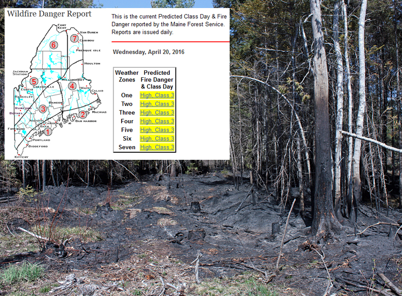
Elevated fire danger potential Wednesday prompts Weather Service statement
The National Weather Service has issued a special weather statement for today, April 20, noting that there is an elevated fire danger this afternoon due to persistent dry conditions, among other factors.
Temperatures are expected the climb into the 50s and lower 60s Wednesday afternoon, and combine with a very dry air mass to produce relative humidity value around 25 percent, according to the NWS.
Northwest winds gusting to near 25 mph will diminish to around 10-15 mph this afternoon, but even the slightest winds can cause outdoor fires to spread rapidly and jump unexpectedly.
The warm temperatures and low humidity values may lead to an elevated fire danger this afternoon, and open burning across the state is not advised today.
A poll of Midcoast fire chiefs Wednesday mornings shows that the majority are not issuing open burning permits at this time. One of the exceptions being made is for blueberry barrens, which are burned this time of year in order to get the plants ready for the growing season.
Some fire departments, such as Camden, Rockport and South Thomaston, don't issue permits on days that the Maine Forest Service rank as High-Class 3 or above. The state uses the federal classification system for fire danger, with 1 being Low and 5 Extreme. Going up the scale, 2 is Moderate, 3 is High and 4 is Very High.
A Class 3 day denotes that "All fine dead fuels ignite readily and fires start easily from most causes. Unattended brush and campfires are likely to escape. Fires spread rapidly and short-distance spotting is common. High-intensity burning may develop on slopes, in concentrations of fine fuel. Fires may become serious and their control difficult, unless they are hit hard and fast while small. The color code for High is yellow.
The warm, dry air will continue into Thursday, when temperatures are forecast to be around the mid-60s in the afternoon along the coast and closer to 70 inland. The weather forecast is for some clouds and a slight chance of some rain Friday, but it won't likely be enough to provide the kind of conditions that will lower the fire danger classification for the Midcoast to Moderate or Low.
Burn permits can be obtained for $7 each through the MFS and are valid on Class 1 and Class 2 days only. For more information on obtaining a burn permit online, click here. Burn permits obtained through a local fire department or municipality are usually free and are required to burn brush piles, wood debris, agricultural burns and in some cases, even campfires.
The weather forecast through the weekend follows.
Wednesday: Sunny, with a high near 55. North wind around 15 mph.
Wednesday night: Mostly clear, with a low around 34. West wind around 5 mph.
Thursday: Sunny, with a high near 66. West wind around 10 mph.
Thursday night: Increasing clouds, with a low around 44. Southwest wind 5 to 10 mph.
Friday: Mostly cloudy, with a high near 60. South wind around 5 mph.
Friday night: A 50 percent chance of showers. Mostly cloudy, with a low around 43.
Saturday: Mostly sunny, with a high near 58.
Saturday night: Mostly clear, with a low around 32.
Sunday: Mostly sunny, with a high near 50.
Sunday night: Partly cloudy, with a low around 33.
Reach Editorial Director Holly S. Edwards at hollyedwards@penbaypilot.com and 207-706-6655.
Event Date
Address
United States