Council winnows options for rail trail conversion
") A sign at the old Upper Bridge Crossing last summer announces Coastal Mountains Land Trust's "Passy Greenway," the organization's vision of a trail connecting its nature preserves in the area. The "Train Rides," were the main attraction but may soon be relegated to a station further down the line. (Photo by Ethan Andrews)
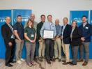
A sign at the old Upper Bridge Crossing last summer announces Coastal Mountains Land Trust's "Passy Greenway," the organization's vision of a trail connecting its nature preserves in the area. The "Train Rides," were the main attraction but may soon be relegated to a station further down the line. (Photo by Ethan Andrews)") Greg Bakos of VHB Engineering presents the results of a rail trail feasibility study to the City Council, Jan. 15. (Photo by Ethan Andrews)
A sign at the old Upper Bridge Crossing last summer announces Coastal Mountains Land Trust's "Passy Greenway," the organization's vision of a trail connecting its nature preserves in the area. The "Train Rides," were the main attraction but may soon be relegated to a station further down the line. (Photo by Ethan Andrews)
Greg Bakos of VHB Engineering presents the results of a rail trail feasibility study to the City Council, Jan. 15. (Photo by Ethan Andrews)
Greg Bakos of VHB Engineering presents the results of a rail trail feasibility study to the City Council, Jan. 15. (Photo by Ethan Andrews)
A sign at the old Upper Bridge Crossing last summer announces Coastal Mountains Land Trust's "Passy Greenway," the organization's vision of a trail connecting its nature preserves in the area. The "Train Rides," were the main attraction but may soon be relegated to a station further down the line. (Photo by Ethan Andrews)
Greg Bakos of VHB Engineering presents the results of a rail trail feasibility study to the City Council, Jan. 15. (Photo by Ethan Andrews)BELFAST - A recreational rail trail along the Passagassawakeag River continued to take shape on Tuesday night as the City Council reviewed a feasibility study and ruled out several of the more expensive options. Watching closely were representatives of Coastal Mountains Land Trust, the Camden-based conservancy that hatched the idea and has pledged money to to the project, and representatives of two railroad groups for whom the trail means being pushed, lovingly, toward the city limits.
The general concept of a recreational path comes from a decade-old CMLT project called the "Passagassawakeag Greenway," which was envisioned as a way to link several of the group's preserves and hiking trail systems along the old Belfast & Moosehead Lake Railroad line.
The city bought a 3.5-mile segment of the rail corridor, from Veterans Memorial Bridge to the Waldo town line in 2010 with the intention of working with CMLT to develop the trail. At the time, the conservancy offered to split the purchase price, but has since taken a step back. Executive Director Scott Dickerson said Tuesday that CMLT is ready to lend its backing, but the organization needs to be able to assure donors that the trail is going to happen before dedicating any money to the project.
"Even today we don't have that complete certainty," he said.
One complication in the project comes from the fact that the rail corridor has not been idle. Over the past several years, Brooks Preservation Society has held leases to operate excursion rail trips between Belfast and Burnham and the group has kept a steady schedule during summer and fall months, operating last year out of the parking lot at the old Upper Bridge Crossing just outside of town.
For a time the city entertained the idea of putting the recreational trail alongside the railroad tracks to allow both uses.
A survey of the land, however, found that this would have been prohibitively expensive, and the city has since opted for "rail-banking," which involves removing the tracks and using the rail bed as a subsurface for the trail. Under this arrangement, restoring the railroad would legally remain an option but the rails themselves would likely be sold to finance the construction of the path.
A feasibility study, presented on Tuesday, included several options for the trail surface, and suggestions for negotiating the obstructed ends of the route. The city-owned portion of the rail line ends just shy of the downtown, separated from Front Street and the footbridge by a stretch of private property owned by Penobscot McCrum. On the north end, the railroad empties onto a busy stretch of Oak Hill Road, just west of Kaler Road, which planners envision as an informal route back to the downtown via the east side of the river.
The other complication at the northern end involves the old City Point Station, which is currently home to a small railroad museum operated by Mack Page and has been considered as an alternative terminal for excursion trains.
Speaking on Tuesday, Page responded to a question posed by Councilor Roger Lee at a previous meeting as to whether the rail interests had a five-year plan.
"I have a 25-year plan," Page said. "And it's coming together very nicely. But if you tear up the rail it's going to hinder us."
Page asked the Council to back the trail up enough to allow trains to operate out of the station, and several members of the Council expressed a desire to come to a compromise that would allow both uses over the last 900 feet of the proposed trail route. Several options for doing this were presented in the study including shifting the rail onto Page's property or shifting the trail to run alongside the existing mainline track.
The first option would add an estimated $80,000 to the bottom line through the reuse of rails that would otherwise be salvaged to cover the cost of the trail. The parallel trail version would add roughly $100,000, primarily to add fill to the steep embankment beside the railway.
Another option suggested in the study would not accommodate the railroad but follow the main track almost to Oak Hill road and use a yet-to-be-negotiated easement with another property owner to reach Kaler Road.
The south end, too, remained somewhat unresolved after Tuesday night's meeting, though the Council ruled out the one proposal in the feasibility study for circumnavigating the Penobscot McCrum property by way of a path from River Avenue. On a drawing in the study, the connector was shown as a dotted line making several switchbacks to navigate the steep embankment leading from the upland road back to the railway. The winding shape along with an estimated $400,000 price tag earned it the derisive nickname "ADA-compliant goat path." As such, it was scratched from the plans without objections from any members of the Council, though no other options were put forward.
The one other decision made by the Council was to rule out paving in favor of a granular surface for the path. The feasibility study indicated that the cost of a fine gravel surface similar to the carriage roads at Acadia National Park could be paid for entirely by selling the rails. Paving would add an additional $400,000.
Councilor Lee said he favored the granular surface but asked the author of the feasibility study, VHB Engineering, to give an estimate of what the city should expect to spend in annual maintenance.
Several residents spoke at a public hearing on the rail trail, including Ashley Messner who said her background as a trail guide should predispose her to supporting the project, but she didn't. Messner said a typical rail trail is "point A to point B with stops in between," but this one had no definitive beginning or end. She also pointed to the absence of a plan for garbage or restrooms.
Glenn Montgomery and Mark Lishner each gave enthusiastic support for the trail, as did Skip Pendleton of the Belfast Bay Watershed Coalition, who said his organization was working on a "necklace" of trails stretching from Little River along an inland route and hopefully back to the river in the vicinity of CMLT's trails or the rail corridor.
"This [the Watershed Coalition plan] would tie right in with the rail trail," he said.
The Council approved taking the "goat path" off the table and planning on a granular surface. Lee added that the decisions were not a vote to spend money, only to narrow the scope of costs in the planning stage.
Contact Ethan Andrews by e-mail at news@penbaypilot.com
Event Date
Address
United States