The earth shook around Belfast. Just a little
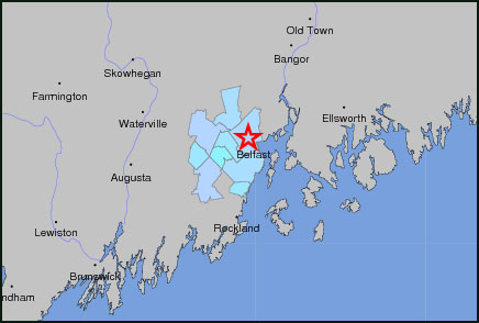
BELFAST —The epicenter of a small earthquake was just two miles northwest of Belfast at 11:25 p.m. on Nov. 23, but it was strong enough, at magnitude 2.0, to be felt in Camden, Morrill and Union, among other towns, with reports of a loud bang.
The depth of the earthquake was at approximately 4 kilometers (2.48 miles).
In Belfast, the intensity was recorded at III on the Modified Mercalli Intensity scale, which depicts shaking severity, according to the Association of Bay Area Governments in Oakland, California.
Read about the Belfast quake at the U.S. Geological Survey
And at the event page
A history of earthquakes in Maine
"An earthquake has a single magnitude that indicates the overall size and energy released by the earthquake," the association says at its website. "However, the amount of shaking experienced at different locations varies based on not only that overall magnitude, how far you are from the fault that ruptured in the earthquake, and whether you are on rock or thick valley deposits that shake longer and harder than rock."
Larger earthquakes taking place on Nov. 23 at various spots on the globe were record in Burma, Puerto Rico, Indonesia and California. Earthquakes are a regular occurence throughout the world, and the Geologic Survey keeps a constant tabs on where they have been recorded with this map.
However, in order to make the map, earthquakes have to reach a magnitude of 2.5; Belfast's was 2.0. There have been 216 earthquakes in the world over the past seven days with magnitude 2.5 and more. The biggest was 5.9 in Chile on Nov. 21.
Citizens filed reports of sensing the Belfast earthquake at U.S. Geological Survey's Earthquakes Hazard Program.
"New England is laced with known faults but numerous smaller or deeply buried faults remain undetected," according to the USG. "Even the known faults are poorly located at the depths of most earthquakes. Accordingly, few, if any, earthquakes in New England can be linked to named faults. It is difficult to determine if a known fault is still active and could slip and cause an earthquake. As in most other areas east of the Rockies, the best guide to earthquake hazards in New England and Long Island is the earthquakes themselves."
The largest earthquake ever reported in Maine occured on March 21, 1904, when, according to the Maine Department of Conservation, "a shock overthrew some chimneys at Calais and Eastport, Maine, and St. Stephen, New Brunswick. The total felt area covered most of New England and the Canadian Provinces of New Brunswick and Nova Scotia, approximately 150,000 square miles. There were several light shocks near the origin a few hours after the main earthquake."
In Maine, earthquakes are not uncommon, according to the Maine Department of Conservation's Bureau of Geology, Natural Areas and Coastal Resources, which compiled the following list.
Maine Earthquakes 1997 to Present
Asterisk (*) indicates earthquakes felt in Maine, but with epicenters outside Maine.
Most microquakes (magnitude less than 2.0), which are generally too small to feel, are not listed here.
(C) indicates a Coda magnitude; all others are Nuttli magnitudes.
Dates are given in local Maine time (EST or EDT).
| Date | Magnitude | Location |
| October 16, 2012 | magnitude 4.0 | East Waterboro, about 13 miles northwest of Saco |
| February 17, 2012 | magnitude 2.4 | T18ED BPP, 11 miles north of Machias, eastern Maine |
| February 17, 2012 | magnitude 2.3 | 12 miles north-northwest of Machias, eastern Maine |
| January 16, 2012 | magnitude 2.1 | 7 miles south-southeast of Allagash, northern Maine |
| December 30, 2011 | magnitude 2.0 | 12 miles south-southeast of Allagash, northern Maine |
| December 12, 2011 | magnitude 2.3 | Sedgwick, about 8 miles southeast of Castine, mid-coast Maine |
| July 7, 2011 | magnitude 2.3 | Brooksville, about 4 miles east of Castine, mid-coast Maine |
| April 30 - May 5, 2011 | magnitude 1.7 and less | Bucksport - Searsport area, microquake swarm |
| March 25, 2011 | magnitude 2.2 | Burlington, about 9 miles southeast of Lincoln, central Maine |
| January 31, 2011 | magnitude 2.0 | near South Robbinston, about 11 miles north-northwest of Eastport |
| January 17, 2011 | magnitude 1.4 | town of Waldo, about 3 miles northwest of Belfast |
| August 29, 2010 | magnitude 2.3 | Hollis, about 9 miles west of Gorham |
| July 29, 2010 | magnitude 2.6 | Northfield, about 12½ miles northwest of Machias |
| June 23, 2010* | magnitude 5.0 | Canada, about 35 miles north-northeast of Ottawa. Felt in southwestern Maine. |
| June 7, 2010* | magnitude 2.9 | offshore, about 11 miles southeast of Boon Island (York County) |
| March 30, 2010 | magnitude 3.0 | near Orrington-Bucksport line, about 7 miles north of Bucksport |
| February 17, 2010* | magnitude 1.7 | offshore of Trescott Township, about 14 miles south-southwest of Eastport |
| February 2, 2010 | magnitude 2.0 | about 8 miles southeast of Masardis (northwest of Houlton) |
| December 7, 2009 | magnitude 1.8 | Gardiner |
| November 19, 2009 | magnitude 2.5 | South Andover, about 6 miles northwest of Rumford Center |
| December 24, 2008 | magnitude 2.2 | Clinton, about 10 miles northeast of Waterville |
| November 13, 2008 | magnitude 2.2 | Newry, about 10 miles west of Rumford |
| October 25, 2008 | magnitude 2.6(C) | Livermore, about 21 miles north of Lewiston |
| October 24, 2008 | magnitude 2.2(C) | Exeter, about 6 miles east of Corinna |
| August 30, 2008 | magnitude 2.7(C) | Wilton, about 5 miles southwest of Farmington |
| August 22, 2008 | magnitude 2.4(C) | Mount Vernon, about 14 miles northwest of Augusta |
| May 30, 2008 | magnitude 2.4(C) | Flanders Bay, about 7 miles northeast of Bar Harbor |
| May 19, 2008 | magnitude 2.4(C) | Presque Isle |
| December 11, 2007 | magnitude 2.2 | Topsham, about 5 miles northwest of Brunswick |
| October 9, 2007 | magnitude 2.0 | Andover, about 12 miles northwest of Rumford |
| October 2, 2007 | magnitude 2.4(C) | Topsham, about 3 miles northwest of Brunswick |
| October 2, 2007 | magnitude 2.3(C) | Lexington Township, about 22 miles northwest of Skowhegan |
| July 16, 2007 | magnitude 2.4(C) | Lewiston |
| March 4, 2007* | magnitude 2.2 | About 10 miles east-southeast of Isle Au Haut (offshore) |
| February 26, 2007 | magnitude 1.7 | approx. 7 miles north-northwest of Ellsworth |
| February 1, 2007 | magnitude 2.1 | approx. 5.5 miles southwest of Augusta |
| December 29, 2006 | magnitude 3.1 | east of Cadillac Mountain, Mount Desert Island |
| December 18, 2006 | magnitude 2.3 | east of Cadillac Mountain, Mount Desert Island |
| October 22, 2006 | magnitude 2.3 | east of Cadillac Mountain, Mount Desert Island |
| October 2, 2006 | magnitude 4.2 | east of Cadillac Mountain, Mount Desert Island |
| September 28, 2006 | magnitude 2.5 | east of Cadillac Mountain, Mount Desert Island |
| September 22, 2006 | magnitude 3.4 | east of Cadillac Mountain, Mount Desert Island |
| August 5, 2006 | magnitude 1.9 | approx. 6 miles west of Byron, western Maine |
| July 14, 2006 | magnitude 3.8 | about 15 miles northwest of Portage, central Aroostook Co. |
| May 31, 2006* | magnitude 1.6 | approx. 23 miles southeast of Machias (offshore) |
| May 29, 2006 | magnitude 1.5 | approx. 7 miles southeast of Dover-Foxcroft |
| January 20, 2006 | magnitude 1.8 | approx. 6 miles southeast of Dover-Foxcroft |
| January 20, 2006 | magnitude 1.7 | approx. 13 miles southeast of Dover-Foxcroft |
| September 25, 2005 | magnitude 3.5 | approx. 8 miles northwest of Pembroke, Washington Co. |
| August 14, 2005 | magnitude 1.9 | China Lake region, northeast of Augusta (poorly located) |
| May 11, 2005 | magnitude 2.4 | approx. 6 miles northeast of Dover-Foxcroft |
| March 6, 2005* | magnitude 5.4 | northeast of Quebec City, Canada (felt widely across Maine) |
| June 22, 2004 | magnitude 2.0 | approx. 6 miles northeast of Dover-Foxcroft |
| March 29, 2004 | magnitude <2.0(?) | felt in Hallowell, Farmingdale |
| March 16, 2004 | magnitude 2.1 | Cape Neddick area (offshore) |
| October 15, 2003* | magnitude 3.1 | approx. 11 miles east of Robbinston, Passamaquoddy Bay |
| August 22, 2003 | magnitude 2.4 | between Waterville and Augusta |
| March 15, 2003 | magnitude 2.2 | Limington-Standish area, southern Maine |
| February 11, 2003 | magnitude 2.1 | approx. 13 miles north of Dover-Foxcroft |
| May 11, 2002 | magnitude 2.5 | approx. 12 miles northeast of Newport (central Maine) |
| April 20, 2002* | magnitude 5.3 | near Plattsburgh, New York |
| March 15, 2002 | magnitude 1.9 | near Brownville Junction (central Maine) |
| February 25, 2002 | magnitude 2.6 | about 4 miles southwest of Bucksport |
| December 27, 2001 | magnitude 2.8 | approx. 35 miles northeast of Bangor |
| October 24, 2001 | magnitude 3.3 | approx. 2 miles south of Howland |
| July 14, 2001 | magnitude 1.7 | approx. 4 miles north of Harmony |
| July 13, 2001 | magnitude 1.7 | approx. 5 miles south of Dover-Foxcroft |
| July 1, 2001 | magnitude 1.3 | approx. 2 miles southwest of Bucksport |
| January 20, 2001 | magnitude 2.5 | approx. 8 miles northwest of Machias |
| September 7, 2000 | magnitude 3.2 | approx. 15 miles southeast of Waterville |
| January 17, 2000 | magnitude 3.4 | approx. 10 miles north of Rumford |
| January 3, 2000 | magnitude 3.4 | Turner-Livermore area |
| December 24, 1999 | magnitude 3.0 | Newport-Etna area |
| July 27, 1999 | magnitude 2.7 | approx. 30 miles south of Allagash |
| July 4, 1999* | magnitude 2.3 | approx. 20 miles southeast of Cutler (offshore) |
| June 9, 1999 | magnitude 1.8 | east of Petit Manan (offshore) |
| February 25, 1999 | magnitude 3.6 | approx. 7 miles southeast of Waterville |
| January 1, 1999 | magnitude 2.3 | Perry-Quoddy area, Passamaquoddy Bay |
| September 16, 1998 | magnitude 2.6 | near West Pembroke (eastern Maine) |
| September 5, 1998 | magnitude 2.3 | near Sedgwick (mid-coast Maine) |
| June 7, 1998 | magnitude 1.9 | approx. 12 miles southwest of Fish River Lake (northern Maine) |
| November 5, 1997* | magnitude 5.1 | near Quebec City, Canada (felt widely across Maine) |
| April 29, 1997 | magnitude 3.0 | near Wilton (central Maine) |
Information Sources: Weston Observatory of Boston College, U. S. Geological Survey, Earthquakes Canada G.S.C., Maine Geological Survey
http://earthquake.usgs.gov/earthquakes/dyfi/events/us/c000dxll/us/index.html
Event Date
Address
United States