Another weekend winter storm watch in effect for Midcoast, southern Maine
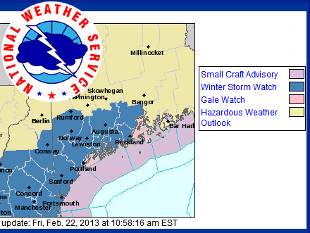
GRAY — Southern and Midcoast portions of Maine are under a winter storm watch from Saturday evening through Sunday evening, with a potential for heavy snow.
As of early Friday morning, the National Weather Service is saying snow accumulations of 6 to 10 inches are possible during the winter storm watch timeframe.
A low pressure across the Great Lakes Saturday is expected to redevelop off the Mid-Atlantic coastline and track northeast toward Nantucket, Mass., by Sunday. Light snow, mixed with rain at times, will likely be ongoing Saturday, according to the NWS, but snowfall will pick up in intensity Saturday evening.
Snow will become heavy at times along interior areas adjacent to the coast, and the storm is predicted to turn more easterly Sunday, causing snows to linger into the evening, especially along the coast.
Temperatures are expected to be around 25-30 degrees Fahrenheit Saturday night, with highs of 30-35 F Sunday, and 5 to 15 mph winds and gusts up to 25 mph along the coast.
The 2-feet of snow that blanketed the Midcoast Feb. 9 was light and fluffy, but the upcoming storm's precipitation will be of the heavy variety, this time bringing a potential for falling limbs and scattered power outages from weight rather than winds.
Event Date
Address
United States


 presents a dyptych pastel by the late Paul Plante to lucky winner Ali Dailey.")