Storm, snow headed to Maine early this week
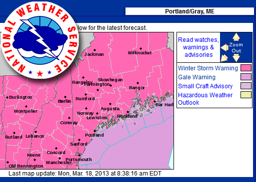
GRAY — The National Weather Service has issued a winter storm warning for Maine, which is in effect from 4 a.m. through midnight Tuesday, March 19.
Snow accumulations of 8-12 inches are possible, along with a potential for scattered power outages due to heavy snow likely in coastal areas.
Winds will be northeast at 10 to 15 mph, with gusts up to 25 mph and temperatures in the mid-20s to lower 30s.
The precipitation may mix with or change to sleet or rain during the day Tuesday. Snowfall rates of an inch or more an hour are possible
The extended forecast, as of Monday morning, follows.
Monday: Sunny, with a high near 33 F. West wind 7 to 10 mph.
Monday night: A 30 percent chance of snow after 4 a.m. Increasing clouds, with a low around 25 F. Calm wind becoming east 6 mph after midnight.
Tuesday: Snow. High near 32 F. Breezy, with an east wind 11 to 17 mph. Chance of precipitation is 90 percent. New snow accumulation of 3 to 7 inches possible.
Tuesday night: Snow. Low around 27 F. Chance of precipitation is 100 percent.
Wednesday: A 40 percent chance of snow showers before noon. Cloudy, with a high near 33 F.
Wednesday night: Mostly cloudy, with a low around 25 F.
Thursday: Partly sunny, with a high near 35 F.
Editorial Director Holly S. Edwards can be reached by email at hollyedwards@penbaypilot.com or by calling 207-706-6655.
Event Date
Address
United States


 presents a dyptych pastel by the late Paul Plante to lucky winner Ali Dailey.")